Featured Rides & Ride Maps
Common Club Rides 20 rides
-
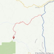
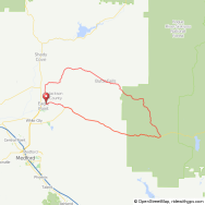
Agate/Antelope Loop
- Distance:
- 29.6 miles
- Elevation Gain:
- 890'
Description:
Rolling hills on the country roads and mostly flat in the residential areas.
-
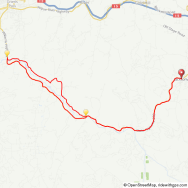
Antelope/Antioch Loop

- Distance:
- 34 miles
- Elevation Gain:
- 1,530'
Description:
This ride takes you over Meadows Road which is a 3 mile climb with most of the gradient around 4-7 %. Once over Meadows you head down toward East Evans Creek Road. It is a short 1 mile to the east and you pick up Antioch Road. Antioch road climbs up to its summit for about 4 miles. Most of the climb is scenic and 4-6%. The last quarter mile ticks up to 9-10%. This is a go...
-
Applegate Dam via Sterling...

- Distance:
- 51.5 miles miles
- Elevation Gain:
- 3,800'
Description:
This route leaves from Jacksonville and starts to climb immediately on Cady Road. Once at the top of Cady you make a left onto Sterling Creek Road. The climb from Jacksonville to the top of Woodrat is approximately 6 miles. There is a great descent for 6 miles to the ghost town of Buncom. Turn right onto Little Applegate Road and continue for 3 miles until you reach Upper A...
-
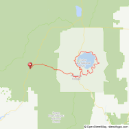
Applegate Lake
- Distance:
- 45 miles
- Elevation Gain:
- 2,400'
Description:
The ride to Applegate Lake and back is possible at just about any time of the year, it just so happens that it's about the best moderate length ride to open the season in the spring. It's a beautiful ride, generally starting in Jacksonville, climbing for roughly two miles and 500 feet before dropping back down to the Applegate Valley. From here on the ride cruises thru the past...
-
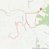
BBQ Loop

- Distance:
- 26.7 miles
- Elevation Gain:
- 1,472'
Description:
This ride starts and ends on Minear Road in SW Medford. Minear Road is just off of S. Stage Road as you near Jacksonville.
-
Brownsboro Loop
- Distance:
- 38 miles
- Elevation Gain:
- 1,100'
Description:
The Brownsboro Loop is one of the most common club rides and one of the more common places to see riders in the north end of the valley. This loop, which comes in at just under 40 miles with about 1,000' of climbing takes in a mix of urban, residential, industrial and rural roads. There are a few rollers leaving Medford and another near Brownsboro, but this is really one of the...
-
Butte Falls Prospect
- Distance:
- 50-72 miles
- Elevation Gain:
- 3,800'
Description:
The Butte Falls/Prospect Loop is an amazing ride into the cascades. It has some good climbing - nothing that will break the legs - and superb scenery. Traditionally the club rides will start at McGregor Park just below Lost Creek Dam. From there immediately turn right on the Crowfoot Rd after crossing the Rogue. After 10 miles of gentle but consistent climbing turn left on the...
-
Elderberry Flats Loop

- Distance:
- 26.4 miles
- Elevation Gain:
- 1,347'
Description:
26.4 miles over mostly flat roads.
-
Galice to Wolf Creek Loop
- Distance:
- 44.5 miles
- Elevation Gain:
- 3,200'
Description:
Ride goes from Galice Resort to Wolf Creek. This is a scenic route along the Rogue River and Graves Creek for much of the route. There are many miles on Graves Creek Road that is a single lane and climbs up above the water. There are many turns with spectacular views below.
-
Jville to Murphy
- Distance:
- 55.2 miles
- Elevation Gain:
- 2,550'
Description:
Ride goes out through Applegate Valley and follows Applegate River for many miles.
-
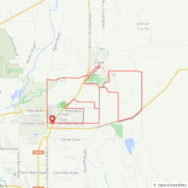
Meadows/Antioch Loop

- Distance:
- 28 miles
- Elevation Gain:
- 1,475'
Description:
This route has views of both Upper and Lower Table Rocks. The East Evans Creek Valley is very scenic. Miles can be added to the route if you want to go to the east end of the road for East Evans Creek. This would add about 8 miles to the route.
-
Reese Creek Loop
- Distance:
- 27.7 miles
- Elevation Gain:
- 850'
Description:
The route is mostly flat and follows country roads with the exception of Hwy 62 which is only at the start of the ride.
-
Reese Creek/Meridian

- Distance:
- 27.7 miles
- Elevation Gain:
- 975'
Description:
This ride takes you through some farm land in the Eagle Point area.
-
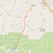
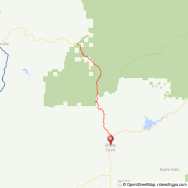
Ride to Callahan's

- Distance:
- 13 miles
- Elevation Gain:
- 1,900'
Description:
The climb to Callahan's is a beautiful ride from the valley floor to 4000 feet. The climb itself isn't terribly difficult but it certainly isn't easy either. The real climb begins half a mile past the right turn onto old highway 99 with an average gradient of just less than 6% for six miles. It twists and turns up the oak woodlands with occasional views of Soda Mountain, Pilot...
-
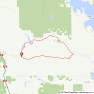
Rogue River to Wimer Loop

- Distance:
- 23 miles
- Elevation Gain:
- 790'
Description:
The route is over secondary roads that follows Evans Creek all the way into Wimer. You will catch glimpses of the creek in several locations. The stop in Wimer is next to an old covered bridge and makes for a scenic photo.
-
Table Rock Loop

- Distance:
- 24 miles
- Elevation Gain:
- 450'
Description:
Easy mostly flat loop out in Sam's Valley area.
-
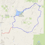
The Lakes Loop
- Distance:
- 52 miles
- Elevation Gain:
- 4,900'
Description:
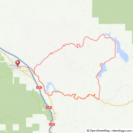
The Lakes Loop is a great training ride in the weeks before the Mountain Lakes Challenge (MLC). It incorporates all of the really hard parts of the MLC and still gets in roughly 50 miles and 5000 feet of cumulative climbing. It is also great in the weeks before the MLC becase the seasonal temperatures are usually pretty comfortable at that point. In summer this loop should be s...
-
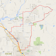
White City/Antelope Loop
- Distance:
- 28.7 miles miles
- Elevation Gain:
- 850'
Description:
This loop starts in White City near the junction of Hwy 62 and Antelope Road...
-
Wimer Loop
- Distance:
- 50 miles
- Elevation Gain:
- 2,000'
Description:
This 50 mile loop is a great way to get off of the busy roads of the Rogue Valley and take mini-break from civilization without significant climbing. Regardless of direction, you'll have one long, but gradual climb and descent with the majority of the ride on flat terrain with minor rollers. If ridden counter-clockwise, your only significant climb is Meadows Rd, which at 3 mile...
-
Woodrat Loop
- Distance:
- 44 miles
- Elevation Gain:
- 2,900'
Description:
The Woodrat ride is a great intermediate length loop that quickly takes you out of the populated Rogue Valley into a forrested rural area. The ride is roughly 46 miles with 3000 feet of climbing. For the most part the climbing is gentle, but W. Griffin Creek road has a short window near its summit that reaches a 16% grade. Once you reach Poorman Creek you'd never know you were...
Hilly Rides 15 rides
-
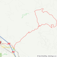
Anderson Gap
- Distance:
- 16 miles
- Elevation Gain:
- 2,600'
Description:
The road to Anderson Gap is one of only a few paved one lane roads that climb into the mountains above the Bear Creek Valley. It does this in spectacular fashion. I enjoy hard climbs. Anderson Gap isn't Sonora Pass in the Sierra Nevada or the Angliru. (a nasty one way climb in Spain w/consistent grades above 20%) It isn't long, but I have found it to be the most difficult climb...
-
Butte Falls Willow Lake Loop
- Distance:
- 62.5 miles
- Elevation Gain:
- 4'
Description:
This route takes you up to the community of Butte Falls and out to Willow Lake. The road to Willow Lake is picturesque and you are afforded many views of Mt McLaughlin as you ride toward the junction of Hwy 140. More than half of this ride is above 4000' so you usually can't ride this until late Spring and into late Fall depending on how much snow is received. You are in the...
-
Cantrall Park Loop
- Distance:
- 16-39 miles
- Elevation Gain:
- 2,500'
Description:
The route up to the top of Cantrall Road is strenuous but worth the effort. You climb through thick fir forests mixed with madrone trees. The average gradient of the climb is 8.9% with the steepest part at 13%. The actual climb is 5.2 miles and gains 2450 feet.
-
Cedar Flats/Deer Creek

- Distance:
- 68-82 miles
- Elevation Gain:
- 4,800'
Description:
Experienced cyclists who've exhausted all of the possible rides and loops in the Medford/Ashland area may not be aware of this very challening loop south of Grants Pass. Like the Conde Creek Loop in the Cascades, this ride through the Siskiyous is a mostly flat/rolling ride interrupted with a massive climb. Like Conde Creek, the heart of the ride is a single lane, chipsealed BL...
-
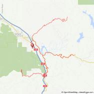
Conde Creek Loop

- Distance:
- 70 miles
- Elevation Gain:
- 5,500'
Description:
The Conde Creek Loop is one of the harder rides the Club will run each year. It is very similar to the Cedar Flats/Deer Creek Loop in that it is generally a rolling/flat ride with one very steep climb accounting for most of the work. That climb is Conde Creek Road, a single lane BLM road that climbs from roughly 2200 feet to 5200 in about 11 miles. That makes it sound hard enou...
-
Crater Lake Loop
- Distance:
- 33-80 miles
- Elevation Gain:
- 3,600'
Description:
This is probably the classic ride in Southern Oregon. It brings everything a rider could want to the table. It's a short 33 mile loop around the lake with several options for starting locations. If you want to extend the ride into an even more spectacular long ride, adding in roughly 45 miles of riding off of the rim can make this an epic ride. I've ridden the loop many times w...
-
Galice to Wolf Creek Loop
- Distance:
- 44.5 miles
- Elevation Gain:
- 3,200'
Description:
Ride goes from Galice Resort to Wolf Creek. This is a scenic route along the Rogue River and Graves Creek for much of the route. There are many miles on Graves Creek Road that is a single lane and climbs up above the water. There are many turns with spectacular views below.
-
Greensprings Keno Access Loop
- Distance:
- 62 miles
- Elevation Gain:
- 4,350'
Description:
This loop will take you through some very scenic areas around two lakes in the cascade range before you get onto the Keno Access Road. The Keno Access Road does a gentle climb up to a summit before it drops down toward Hwy 66 where it meets the Klamath River. There are a couple of spots on the ride up the this summit where you can get some good views of Mt. Shasta on a clear...
-
Mt. Ashland

- Distance:
- 47 miles
- Elevation Gain:
- 5,200'
Description:
There aren't many places around with views like you get on the Mt. Ashland Road. Once you clear the initial mile you are thousands of feet above the landscape below and the horizon opens up. Mt Shasta dominates the view to the south with Mt Eddy, the nearby Siskiyous and the Marble Mountains filling the horizon. Once you reach the ski area summit at 6,600 feet, the view to the...
-
Ride to Callahan's
- Distance:
- 13 miles
- Elevation Gain:
- 1,900'
Description:
The climb to Callahan's is a beautiful ride from the valley floor to 4000 feet. The climb itself isn't terribly difficult but it certainly isn't easy either. The real climb begins half a mile past the right turn onto old highway 99 with an average gradient of just less than 6% for six miles. It twists and turns up the oak woodlands with occasional views of Soda Mountain, Pilot...
-
Salmon River Loop
- Distance:
- 100 miles
- Elevation Gain:
- 10,500'
Description:
If any ride speaks to the rugged beauty of the State of Jefferson, the very challenging Salmon River Loop does it in spades. This 100 mile loop is in the middle of one of the least developed and most remote tracts of land in the lower 48. Once out of the relative bustle of the Scott Valley, you'll probably have the road to yourself - if you need more than one hand to count the...
-
Shale City
- Distance:
- 34 miles
- Elevation Gain:
- 3,900'
Description:
This is a short but rigorous loop. It climbs part of Dead Indian Memorial Road before going onto a paved single lane road. The Shale City Road is about a 10 mile loop that returns to Dead Indian Memorial Road at the summit. You will be in forests most of the time and there is a lot of shade even during the summer months. Shale City Road is a county road and is therefore mai...
-
The Lakes Loop
- Distance:
- 52 miles
- Elevation Gain:
- 4,900'
Description:
The Lakes Loop is a great training ride in the weeks before the Mountain Lakes Challenge (MLC). It incorporates all of the really hard parts of the MLC and still gets in roughly 50 miles and 5000 feet of cumulative climbing. It is also great in the weeks before the MLC becase the seasonal temperatures are usually pretty comfortable at that point. In summer this loop should be s...
-
Trail to Tiller Loop
- Distance:
- 56 miles
- Elevation Gain:
- 4,500'
Description:
This ride will go through some heavily forested areas and along Trail Creek and Elk Creek . There are canyon views on both sides of the hill you climb with the most scenic being along Elk Creek as you near Tiller. You have a climb in both directions and each is about 6 miles in length. The southern climb has an average gradient of 5-6& with the steepest part about 9%. The...
-
Triple Peak Challenge
- Distance:
- 92 miles
- Elevation Gain:
- 11,666'
Description:
Looking for something a bit out of the ordinary? Try riding to the top of Dead Indian, Mount Ashland and the Greensprings in one day. The total elevation gain for the 92-mile thigh-burner, dubbed the Triple Peak Challenge, is 11,666 feet.
More Flat Ride 10 rides
-
Agate/Antelope Loop
- Distance:
- 29.6 miles
- Elevation Gain:
- 890'
Description:
Rolling hills on the country roads and mostly flat in the residential areas.
-
Antelope/Antioch Loop
- Distance:
- 34 miles
- Elevation Gain:
- 1,530'
Description:
This ride takes you over Meadows Road which is a 3 mile climb with most of the gradient around 4-7 %. Once over Meadows you head down toward East Evans Creek Road. It is a short 1 mile to the east and you pick up Antioch Road. Antioch road climbs up to its summit for about 4 miles. Most of the climb is scenic and 4-6%. The last quarter mile ticks up to 9-10%. This is a go...
-
BBQ Loop
- Distance:
- 26.7 miles
- Elevation Gain:
- 1,472'
Description:
This ride starts and ends on Minear Road in SW Medford. Minear Road is just off of S. Stage Road as you near Jacksonville.
-
Elderberry Flats Loop
- Distance:
- 26.4 miles
- Elevation Gain:
- 1,347'
Description:
26.4 miles over mostly flat roads.
-
Meadows/Antioch Loop
- Distance:
- 28 miles
- Elevation Gain:
- 1,475'
Description:
This route has views of both Upper and Lower Table Rocks. The East Evans Creek Valley is very scenic. Miles can be added to the route if you want to go to the east end of the road for East Evans Creek. This would add about 8 miles to the route.
-
Reese Creek Loop
- Distance:
- 27.7 miles
- Elevation Gain:
- 850'
Description:
The route is mostly flat and follows country roads with the exception of Hwy 62 which is only at the start of the ride.
-
Reese Creek/Meridian
- Distance:
- 27.7 miles
- Elevation Gain:
- 975'
Description:
This ride takes you through some farm land in the Eagle Point area.
-
Rogue River to Wimer Loop
- Distance:
- 23 miles
- Elevation Gain:
- 790'
Description:
The route is over secondary roads that follows Evans Creek all the way into Wimer. You will catch glimpses of the creek in several locations. The stop in Wimer is next to an old covered bridge and makes for a scenic photo.
-
Table Rock Loop
- Distance:
- 24 miles
- Elevation Gain:
- 450'
Description:
Easy mostly flat loop out in Sam's Valley area.
-
White City/Antelope Loop
- Distance:
- 28.7 miles miles
- Elevation Gain:
- 850'
Description:
This loop starts in White City near the junction of Hwy 62 and Antelope Road...
Northern California Rides 4 rides
-
Colestin Loop
- Distance:
- 19 miles
- Elevation Gain:
- 2,200'
Description:
If you want to quickly get very far into California by bike from Ashland you either have to be brave (enough to ride on the freeway for a short distance) or be willing to get in touch with your dirty side... why not mix in both? On Nov. 2nd 2002, Wil Thomson, Carol Lee Rogers, Rick Berlet, Bob Korfhage and Cindy Roche challenged the idea that the Siskiyou Velo is just a club fo...
-
Little Shasta Loop

- Distance:
- 65 miles
- Elevation Gain:
- 2,500'
Description:
One of the most scenic and pleasant rides in close proximity to Medford and Ashland, this route is pure cycling pleasure on any nice day of the year. In the winter months a later start, 10:30 or 11:00 am, may avoid the colder air at the somewhat higher (than the Rogue Valley ) elevations of this ride. Similarly, an earlier start in the summer months can avoid the time bake of t...
-
Salmon River Loop
- Distance:
- 100 miles
- Elevation Gain:
- 10,500'
Description:
If any ride speaks to the rugged beauty of the State of Jefferson, the very challenging Salmon River Loop does it in spades. This 100 mile loop is in the middle of one of the least developed and most remote tracts of land in the lower 48. Once out of the relative bustle of the Scott Valley, you'll probably have the road to yourself - if you need more than one hand to count the...
-
Scott River Loop
- Distance:
- 90 miles
- Elevation Gain:
- 3,800'
Description:
This ride make a large loop through Yreka, Ft. Jones, and the Scott River Valley. There are many views as you follow the Scott River and Mt Shasta can be seen in the distance. The biggest climb is as you leave Yreka and head toward Ft. Jones. The average gradient of the climb is 5.5-6% with the steepest part about 10% for a short stint. There are excellent canyon views on H...
Dirt Rides 2 rides
-
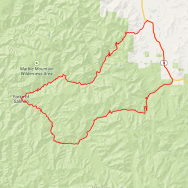
Ashland Watershed Loop

- Distance:
- 27.5 miles
- Elevation Gain:
- 3,500'
Description:
Nothing about this ride is ordinary; the road is single-lane decomposed granite, the route is remote (like cycling in the wilderness), and the surrounding landscape is breath-taking. You'll ride for hours through Southern Oregon's best managed forest; where motorized vehicles (this includes electric bikes) are prohibited. It is a ride that you will never forget. The City of...
-
Colestin Loop
- Distance:
- 19 miles
- Elevation Gain:
- 2,200'
Description:
If you want to quickly get very far into California by bike from Ashland you either have to be brave (enough to ride on the freeway for a short distance) or be willing to get in touch with your dirty side... why not mix in both? On Nov. 2nd 2002, Wil Thomson, Carol Lee Rogers, Rick Berlet, Bob Korfhage and Cindy Roche challenged the idea that the Siskiyou Velo is just a club fo...